Championship No 4 - Bukit Berapit Rail Tunnel and Bridge
 |
| Bukit Berapit Rail Tunnel |
 |
| Bukit Berapit Rail Bridge |
 |
| We started from Taiping after breakfast and took A109's Jalan Air Kuning. Pictured here is Jalan Mat Kassim @ https://maps.app.goo.gl/GWU4wEBgpbYjAW4K7 |
 |
| The bridge leading to LT D' Chalet @ https://maps.app.goo.gl/QoXpakyCrdjhYQj97 |
 |
| The chalet in the background |
 |
| LT D' Chalet @ https://maps.app.goo.gl/LAfKfJ8zHnBN5KHEA |
 |
| You can see the new electrified double tracking railway line from here |
 |
| Going under the new electrified double tracking railway bridge |
 |
| Going under the new electrified double tracking railway bridge |
 |
| Almost immediately after going under the new railway bridge, we spotted the old railway line. However, the railway tracks have since been removed. |
 |
| Initially, the old line runs parallel to the stream below @ https://maps.app.goo.gl/xC3tNVP8rMw8WT3k7 |
 |
| Soon we lost sight of the stream and began a gentle climb to the tunnel and bridge |
 |
| As we are cycling on a former railway tracks, the path is strewn with gravel |
 |
| Bumpy ride on a Brompton |
 |
| About 500m from LT D' Chalet, we reached the old railway tunnel @ https://maps.app.goo.gl/xUx7S4C348ktbWhg7 |
 |
| The tunnel is about 500m in length and quite straight, hence you can see from one end to the other. |
 |
| This is NOT a selfie! You can see the team reflected in the sunglasses |
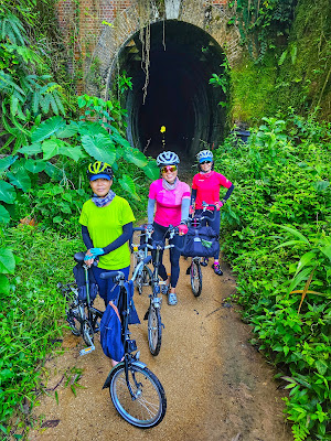 |
| Girls Power |
 |
| The tunnel opening is laid with red bricks... |
 |
| ...deeper in, it is just raw rocks! |
 |
| This tunnel is part of a series of 4 tunnels built in 1898 to complete the railway line between Ipoh and Prai. This said railway line was opened to service in 1903 but subsequently abandoned in 2013 when the new electrified double tracking system took over. KTM's ETS and Commuter trains uses this new line which somewhat runs parallel to the old line. |
 |
| Strangely, we spotted a fish inside the tunnel... |
 |
| ...and some freshwater prawns... |
 |
| ...even bats!!! |
 |
| At this point, we were praying hard they don't defecate on us! |
 |
| Light at the end of the tunnel |
 |
| Outside again |
 |
| The other opening end is also fortified with red bricks. The original railway tracks were said to be removed in 2017 |
 |
| This was part of the MMTF route in 2022, an ultramarathon with a 100 km distance @ https://maps.app.goo.gl/ZHk69iFYLXTpYYKa7 |
 |
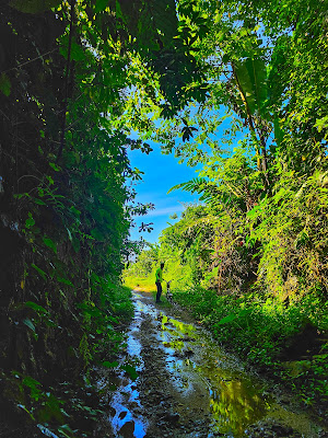
| The trail was somewhat overgrown in certain areas @ https://maps.app.goo.gl/TBac6b5iqfWgv3TCA |
 |
| Boy, were we relieved to find a credible path... |
 |
| ...even though it was water logged! |
 |
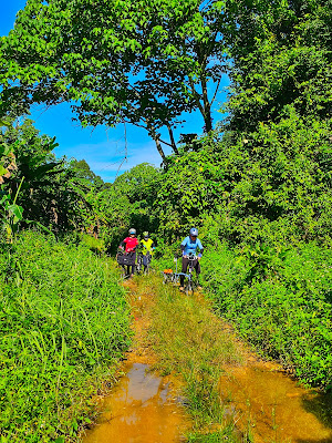
| At times, the trail narrowed to a single track |
 |
| A shallow stream... |
 |
| ...fed by spring water! We were relieved to see a farmer collecting freshwater here. He helped to affirm that we were still on track for the railway bridge @ https://maps.app.goo.gl/bDkp9X4cvFWZ2yhw7 |
 |
| It is a strange journey. We keep getting in and out of overgrown trails. In this case, we were relieved to be out in the open with a clear view of the path @ https://maps.app.goo.gl/u1GZB4zwNs8MVKLo9 |
 |
| Here's us, just out of another pickle and with the forest behind us. The earlier photo with the blue sky was only 100 m behind @ https://maps.app.goo.gl/BzuH6GreGL9gz8bH6 We were relieved to meet a farmer resting on this shed. He confirmed we were on the right track to the old railways bridge. 50m away from this shed, we entered another set of abyss! |
 |
| As mentioned earlier, the new electrified double tracking system runs somewhat parallel to the old line so we could hear the sound of the train quite often. Over here is a high vantage point to view the new line @ https://maps.app.goo.gl/o77SJ1HiaZySsvw4A |
 |
| There's a waterfall along the route too! |
 |
| Waterfall @ https://maps.app.goo.gl/rEHF4mHyYL4g39yu5. There's an escape route near this waterfall but we persisted as we have yet to find the old railway bridge |
 |
| From the farmer's shed to the high vantage point to the waterfalls, we were travelling through lush greenery |
 |
| The ground is damp here |
 |
| Location @ https://maps.app.goo.gl/LhY8SPpetx4QdPsn7 |
 |
| Elated to be out in the open again! |
 |
| Even though the trail is overgrown here... |
 |
| ...no visible trail... |
 |
| ...there's an abandoned shed to our right! @ https://maps.app.goo.gl/mJ3WbrNRVUQUBiFP6 |
 |
| This other shed has lifestock |
 |
| Goats and sheep |
 |
| Location @ https://maps.app.goo.gl/poCpvmt7ajux4foH9 |
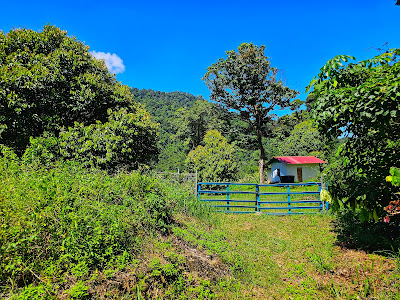 |
| To the left of this farm house is our escape route but not before we find our railways bridge And so, we persisted... |
 |
| ...this time, we were literally riding into a wall of shrubs, not knowing what lies ahead! |
 |
| But lo and behold, we were greatly rewarded with our persistence @ https://maps.app.goo.gl/4JNbtHoWUQ9wEPfU7 This railway bridge is about 7 km from LT D' Chalet |
 |
| Not everyone enjoys heights... |
 |
| ...but some are daredevils! |
 |
| It goes down a few more stories |
 |
| The waterfalls is not visible from this bridge but the stream flows beneath this bridge |
 |
| So, we returned to the farmhouse with blue gates and made our way out of the trail... |
 |
| Cross this bridge and you can already see Federal Route 1 ahead. View of Federal Route 1 and the trail we exited @ https://maps.app.goo.gl/XrWEFsqs62roVVfg7 |
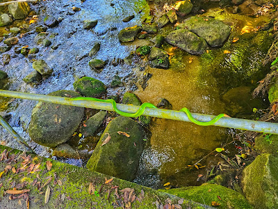 |
| Claudine almost leaned against this snake to capture a photo of her parked bike. She let out a blood curdling scream! |
 |
| Durian at Kampung Pauh @ RM10 per kg |
 |
| Right in front of a muslim cemetery |
 |
| Very lemak kampung durian |
 |
| Jalan Enam Kaki is really only 6 feet wide @ https://maps.app.goo.gl/ErM6YXtsC7tVfd7d9 |
 |
| Cooling down at Spritzer Eco Park |
 |
| Taking the overhead bridge across Jalan Air Kuning... |
 |
| ...to buy traditional biscuits from Biskut Tupai Mas @ https://maps.app.goo.gl/3GtKeB6pN1LGVULF8 |
 |
| A short stop at Taiping Lake Gardens before heading home |
 |
| We were lucky there was a trial run to make this section of the road car free! |
 |
| Bloodcount... |
 |
| The trail takes your blood! |
 |
| Payment for passage across |
 |
| Circled in blue is the route from LT D' Chalet to the Old Railway Bridge |