Championship No 1 - Historic New Ferry Service
 |
| The team, having our first dinner together at Golden Corner on Sunday night. Mindy had come by train while Henry had driven Mr Lim and Zoe, all the way from JB. As for Claudine, she had arrived in KL on Saturday morning to join her girlfriends for a reunion before driving down with May the next day. |
 |
| Leaving Claudine's old kampung house @ 7.20 am |
 |
| 15 minutes later and after May suffered a fall on the way up Drummond Hill, right next to Taman Vista Hill, we arrive at Taiping Gaol. She had trouble changing her gears and lost her balance when she stopped. The bushes literally swallowed her up. later, she learnt she had lost her sunglasses. |
 |
| Still in 1 piece and totally unaffected by her fall, May is having breakfast here with the gang at Tai Chien coffee shop |
 |
| After breakfast, we went to the railway station to secure our train tickets for Butterworth. May is pointing to KTM's notice on "bicycle on board" policy. The RM2 charge for bicycles are waived to promote a healthy lifestyle. Meanwhile, foldable bicycles are allowed on all KTM commuters at all times except from Butterworth to Padang Besar. However, there are some time restrictions for full sized bikes during the weekdays. |
 |
| After buying our train tickets, we did a bit of sightseeing around Taiping. Behind us is the old pedestrian bridge across the old railway station. When the new electrified double tracking system was built to replace the old one, this pedestrian bridge got in the way of the electric cables and had to be removed. The salvaged pieces are reconstructed behind the Taiping post office. |
 |
| An old locomotive is also placed here |
 |
| How not to love Taiping? It is so beautiful |
 |
| District and Land Office @ 1897 |
 |
| On the overhead pedestrian bridge at the railway station |
 |
| The all new Taiping Railway Station. Meanwhile, the first railway station in Malaysia is dwarfed and left desolate in the same vicinity |
 |
| Bikes are all folded up |
 |
| The samseng 75 year old lady |
 |
| Here comes the train, right on schedule @ 9.47 am. You can download KTMB app to purchase the tickets online. The journey from Taiping to Butterworth costs RM7.50 |
 |
| Our bikes goes to the baggage area |
 |
| KTM commuter comes with clean and comfortable coaches |
 |
| Priority seats for senior citizens are in blue upholstery |
 |
| The train crossing the Prai River. The suspension bridge in the photo is part of the E17, Butterworth Outer Ring Road |
 |
The train was on schedule, arriving in Butterworth at 10.51.
Here, we are proceeding towards the ferry terminal. The railway station and ferry terminal are somewhat connected for pedestrians ease but the officers sometimes require you to fold your bike or may try to boot cyclists to use the road instead. We managed to push our bike upon our arrival in Butterworth but on our return route, we had to negotiate and only allowed to use the pedestrian walkway with our bikes folded up.
| It's quite a lot of work to get to the ferry terminal. The train tracks are on the ground. We had |
to take the lift up to get to the pedestrian walkway. The first walkway as pictured above is part of The Penang Central building, hence it is air-conditioned. At the end of this covered walkway which leads to Penang Central, we then take the connecting open air walkway to the ferry terminal. Then another lift to get to the ground before following the motorcycle queue for the ferry |
 |
| Photo credit : Google Maps for visuals |
 |
Waiting for our ferry.
|
 |
| Bicycles follow the 2 wheeled vehicle queue |
 |
| The new ferry service is only available to pedestrians and 2 wheelers |
 |
| IMO9977622 Teluk Kumbar is part of the 4 new state of the art ferries which replaces the old iconic ferries |
 |
| On board the new ferry with the ramp up and ready for sailing |
 |
| Thumbs up for a free ride during its first month of service |
 |
| Always stand nearest to the life ring bouys if you don't know how to swim! |
 |
| Penang ahead |
 |
| Penang Bridge |
 |
| Butterworth |
 |
| There's a clear segregation between pedestrians and 2 wheeled vehicles |
 |
| Air-conditioned area |
 |
| Priority seats |
 |
| Toilets |
 |
| Stainless steel latrine! Hopefully the ferry's engine is loud enough to muffle the sounds amplified by the metal bowl ! |
 |
| Pull down seats to rest your tired feet (photo taken on our return journey) |
 |
| Section for 2 wheelers with a few pull down seats on the right |
 |
| We got off from Pengkalan Raja Tun Uda and rode along Pengkalan Weld. After our 1st insignificant lunch, we proceeded to Kafe Ping Hooi for yummy lobak and fried kueh tiau @ https://maps.app.goo.gl/uTfKAzdNb4EzDzFz5 |
 |
| Extremely hot afternoon at 1.45 pm. Karpal Singh Drive with Penang Bridge in the background. |
 |
| On Penang Cycle Lane, right after Fisherman's Wharf and near to Hean Chooi Temple. |
 |
| We had wanted to follow the cycle lane all the way to Batu Maung but the cycle lane at this section was closed. Traffic on Jalan Tun Dr Lim Chong Eu Highway was murderous, so we had to turn back @ https://maps.app.goo.gl/2Zb3zxUibdJ87yZ66 |
 |
| As per review, it is closed! |
 |
Abandoned jetty that looks like a whale's skeleton on Penang Cycle Lane, right after Fisherman's Wharf and near to Hean Chooi Temple.
|
 |
| Arriving at our stay at 1 Gurney Drive |
 |
| Mother and daughter |
 |
| View from 15th floor |
 |
| Gurney Waterfront, work in progress |
 |
Andaman Island, a reclaimed island by E&O
|
 |
| Swettenham Pier Cruise, jetty jutting out to the sea. In the center, further away is Penang Port, located in Butterworth and on the mainland |
 |
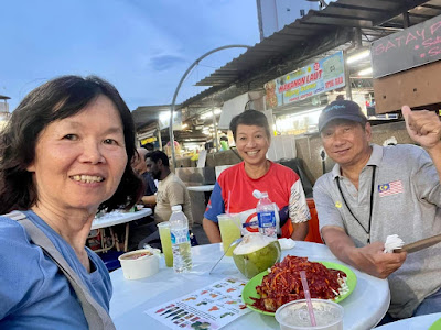
| Evening dinner at Gurney Drive with Wilson CH Gan and Shereen |
All about the old iconic ferries, how they began their service and where they are today!
https://www.thestar.com.my/metro/metro-news/2023/11/29/nostalgia-of-voyages-past -------------------------------------------------------------------------------------------------------------------
1, Gurney Drive