 |
| Moses parted the Red Sea for us!!! |
 |
| Fort Supai |
 |
| It had rained very early last night. In fact it was a huge storm and the resort grounds were partially flooded. The staff had to bail water out and clear the gutters during the storm. In the morning, grey clouds accompanied by light drizzle greeted us at push off time. Not wanting to get caught in the rain even before breakfasts, the first team left the resort to recce for breakfast. The other team members followed suit. David was the last to catch up having to swap bikes with Irene who decided not to ride but her bike was too big to be loaded into the car. Meanwhile, it was arranged for Kelvin and Jasmine to drive Jayden and Irene back to Melaka. Photo here is taken at Jalan Politeknik 30, after our breakfasts at Restoran Selera Simpang, Kampung Sungai Menyala |
 |
| Shortcut attempt failed at Kampung Sungai Menyala! We proceeded to Route 364's Jalan Pintas Teluk Kemang instead |
 |
| Route 5 narrows from a 4 lane road to a 2 lane road as it approaches Pasir Panjang town |
 |
| First right turn after crossing Linggi River, on our way to Fort Supai |
 |
| Big black rubber bouy covered with tyres... |
 |
| ...near the marine shipyard... |
 |
| ...perhaps belonging to LKIM |
 |
| Concrete jetty to Fort Supai |
 |
| View from the floating restaurant towards Kampung Nelayan, Kuala Sungai Baru |
 |
| Tip of the cape |
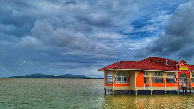 |
| Floating Restaurant |
 |
| Thumbs up |
 |
| Short flight of steps to Fort Supai, a Dutch fort |
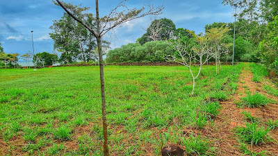 |
| The fort is nothing more than a green field surrounded by walls |
 |
| Abandoned and left to ruins, Fort Supai was once a Dutch stronghold to fend off enemy attacks and to monitor maritime movements on the Straits of Malacca. It also functioned as a tax collection center for tin ore brought out from Rembau and Linggi |
 |
| Fort Supai has many nicknames. The name Supai stuck because of Dutch mercenaries called Sipoi were once stationed here. It is also called Fort Kuala Linggi because of its location at the mouth of Linggi River. Another name was Philipina Fort, named after the daughter of the Governor General of Dutch East India Company, Jacob Mosel. It is also called Kota Meriam Patah or Broken Canon Fort as these were found in the area BUT the cannons featured in the photos were definitely NOT originally from the fort!!!! |
 |
| A with many names....but Supai stuck! |
 |
| On our way to Pantai Beting Beras Basah |
 |
| On our way to Pantai Beting Beras Basah |
 |
| Pantai Beting Beras Basah...newly paved road running alongside the coast |
 |
| Pantai Beting Beras Basah...newly paved road running alongside the coast |
 |
| Pantai Beting Beras Basah at high tide |
 |
| After the beach area, we followed the road to a graveyard... |
 |
| ...and found a secret corner by the sea! |
 |
| Rocky sea front |
 |
| Sea side |
 |
| Toilets and simple kitchen makes it perfect for camping. However, you may have a lot of "visitors" at night!!! |
 |
| It was not easy to take this photo as everyone (or almost!) had to balance on a log!!! |
 |
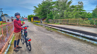
| On Route 138's Jalan Kuala Sungai Baru / Kuala Linggi |
 |
| Off Route 138, on Lorong Pusara Aman |
 |
| Pantai Kg Tengah, Kuala Sungai Baru |
 |
| Bridge across Sungai Baru |
 |
| The mouth of the river @ Sungai Baru |
 |
| Pasar Nelayan Kuala Sungai Baru |
 |
| On the way to brunch, side road to De Muara Ikan Bakar, Kuala Sg Baru |
 |
| On the way to brunch, side road to De Muara Ikan Bakar, Kuala Sg Baru |
 |
| De Muara Ikan Bakar, Kuala Sg Baru's breakfast fares includes lontong, soto and mee kari |
 |
| Decent food |
 |
| On the beach near Pulau Konet with view of Pulau Kamat in the distance |
 |
| Taking the walk of faith |
 |
| Left view from the middle of the sand bank |
 |
| The tide was receeding... |
 |
| ...local anglers said the sand bank will be revealed within an hour but we couldn't wait !!! |
 |
| On Pulau Konet, a tidal isle |
 |
| On Pulau Konet with the mainland in the background |
 |
| On our back to the mainland. Note the waves beating on the sandbank |
 |
| Pulau Konet in the background |
 |
| One last dip before getting back on the main land |
 |
| Approaching Pulau Kamat, another tidal isle |
 |
| Closer view |
 |
| The road leading to the isle |
 |
| Comparing the rocky patch and the tiny strip of sand trail, we suspect Pulau Kamat's sandbank is only inundated in sea waters on very high tide seasons |
 |
| Pulau Kamat |
 |
| Rocky |
 |
| View of Masjid As-Sakinah, Kampung Baru, Kuala Sg Baru from Pulau Kamat |
 |
| Ships in the Horizon as viewed from Pulau Kamat |
 |
| On our way out from Pulau Kamat |
 |
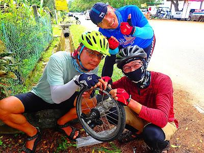
| Major puncture on VT's rear tyre, a few kilometers from Asam Pedas Pantai Selera Bonda, Pantai Sungai Tuang |
 |
| Some of the technical crew chasing glamour!!! |
 |
| No wonder the hissing sound was so loud despite the heavy traffic! |
 |
| The internal wall |
 |
| The culprit |
 |
| Traffic was crazy on the narrow coastal road running alongside Pantai Padang Kemunting, Pengkalan Balak |
 |
| Tanjung Bidara Beach is located right next to Terendak Army Camp |
 |
| Tanjung Bidara Beach |
 |
| Entering Melaka and not long after Uncle KC left us, we were caught in a huge thunderstorm. Initially, we seeked cover at Mini Stadium Bistari along Jalan Ayer Keroh Lama. When the rain was not as heavy, we pushed on only to be caught in a bigger downpour. Above photo is taken outside the Chief Minister Office at Jalan Seri Negeri. After a 10 minutes wait, we decided to brave the rest of the journey as it was only another 4.5 km and the rain unlikely to let up. Jalan Gapam right below the Chief Minister's office was flooded. The entire Brompton tyre was underwater! |
 |
| We arrived back at Paku Pakis Resort around 5 pm while it was still raining heavily. They allowed us to use the 2 toilets in the kitchen to change and shower. While the rest did this, some preferred to drive to Petron as the petrol station's big roof made it easier to rearrange the things in the car. The JB team met again at Restoran Aunty Lee at Ujong Pasir for dinner before joining the long jam home! |
No comments:
Post a Comment