 |
| Ban Prakob CIQ @ 10 am |
 |
| Breakfast at 7.30 am It had rained the whole night. As morning broke, it was still raining but thankfully, the sky cleared for us when we set out. Thus, we managed to cycle 6 km out to Ban Sathon town for breakfast without getting wet! Sit down breakfast meals are all rice with dishes in this town. Grateful we managed to supplement our rice meals with some traditional kuih muih 50 m from this stall |
 |
| This stall is right outside "Cowboy Thailand" which looks like a pub. It is located right opposite Wat Sathon @ https://maps.app.goo.gl/JAhayj3gyRs1W8BQ7 |
 |
| Street view of Ban Sathon |
 |
| Engorged river on Route 4113 @ https://maps.app.goo.gl/H37BxNZ527quaoau9 |
 |
| It started drizzling as soon as we finished breakfast. The clouds ahead will mean more rain throughout the ride! |
 |
| Gorgeous road with hardly any cars |
 |
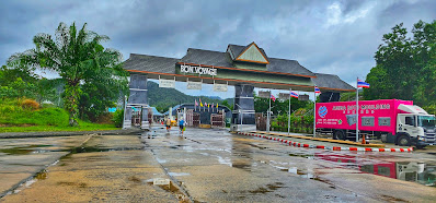
| 9 am at the gates to Ban Prakob CIQ. The actual passport control is still another 500 m ahead. Note the security and truck! |
 |
| Ban Prakob CIQ @ https://maps.app.goo.gl/LaK4Cps58i7PufrX7 |
 |
| Scenic ride to the passport controls |
 |
| Approaching the passport controls |
 |
| Closing in on the passport controls |
 |
| Rear view |
 |
| A temple to receive blessings for the onward journey |
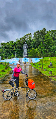 |
| Statue of a revered Buddhist Monk |
 |
| 5 baby elephants!!! |
 |
| Follow the sign |
 |
| Clean and modern toilet facilities at Ban Prakob CIQ |
 |
| We followed the car lane right to the booth but were told to park our bikes and enter the immigration office to get our passports stamped... |
 |
| ...then we returned to collect our bikes and ride through! |
 |
| Bye Thailand! @ 10.15 am |
 |
| 20 m from the gates, and we have entered into Malaysian borders |
 |
| Kota Putra, Durian Bunga CIQ in green |
 |
| Kota Putra CIQ is fondly referred as Durian Burung because the road leading to the CIQ is Jalan Durian Burung |
 |
| Pleasantly, there's a motorcycle lane at this CIQ, hence we do not need to disembark to get our passports stamped |
 |
| Spotted ! Local cyclists enjoying the climb to Kota Putra CIQ on relatively low traffic |
 |
| Alor Setar is another 63 km away. We are heading to KTM Alor Setar to board our train for Taiping |
 |
| Gorgeous roads with light mists of rain here |
 |
| Customs Officers housing on the right while there's a duty free shop on the left |
 |
| Jalan Durian Burung is a low traffic, winding road |
 |
| When bored, take wefie! |
 |
| ...and more wefie!! |
 |
| Glow in the dark paint adopted in Jalan Padang Sanai, Kuala Nerang towards Durian Burung. The paint, formulated with additive glass beads which reflect lights up tp 10 hours is a project mooted by Kementerian Kerja Raya to enhance road safety. After Hulu Langat, Jalan Padang Sanai is the 2nd road in Malaysia to adopt this paint and with a length of 3km is the longest in the country, presently. The same paint will used on designated rural roads all over the country, with Johor slated next. |
 |
| Wat Thai Pradit Tharam |
 |
| Taking a rest after the short climb to the junction to Malaysia Rubber Board. Nearby is Kedah Rubber City in Kuala Nerang |
 |
| Wide roads built in anticipation of great development in Kedah Rubber City. Note that Junior has been leading the ride since Kota Putra CIQ |
 |
| On Route K11, Kampung Chuchoh @ https://maps.app.goo.gl/QM8ZFRwzjmtFu3e77 |
 |
| Right after crossing Sungai Padang Terap with the Kuala Nerang Post Office on the left @ https://maps.app.goo.gl/J8kMgNKqXhMQynYB7 |
 |
| Rear view. Note the bridge which traversed Sungai Padang Terap |
 |
| Spoilt for choice at Kedai Makan Jalan Hospital @ https://maps.app.goo.gl/mhu6uAm3vLmyN7VH7 |
 |
| SMK Dato Syed Ahmad, a cluster school to our left @ https://maps.app.goo.gl/BPLEGsWHCXeHpKDQA |
 |
| Pokok Sena junction @ https://maps.app.goo.gl/u8hAPTyWr11yvZ6U8 |
 |
| District Land Office, Pokok Sena |
 |
| Masjid An Nur, Pokok Sena |
 |
| Langgar means crash...a strange name for a place. Photo taken on Route 175's Jalan Langgar! Thankfully, we completed the ride safely!!! |
 |
| Sweeping green fields of paddy @ https://maps.app.goo.gl/jw4BxcfR86rkG12P7 |
 |
| Junction between Route 175 and 256 |
 |
| Note the egrets on the muddy field |
 |
| Fields ploughed and ready for planting. Note the egrets feasting on the muddy field |
 |
| Souq, a shopping mall in Alor Setar |
 |
| A fleeting view of Masjid Al Bukhari |
 |
| Taking the cycle lane off Route 256 to KTM Alor Setar @ https://maps.app.goo.gl/L4jyeZ7jdf9Q57pu8 |
 |
| Inside the viaduct |
 |
| Getting out from the viaduct with the flyover of Route 256 above us |
 |
| Waiting for our 3.18 pm train which was delayed. Earlier, we had packed our bikes outside the train station and took turns to change and clean up. If we had known the train will be delayed, we wouldn't have rushed! There was also a big Brompton group waiting to catch the same train with the same IKEA dimpa bag. A secret nod as salutation to common comrades! As the train was delayed, it was jam packed. We had to stand most of the way with Junior separated and in an awkward position by the door. His situation worsened as the train picked up more and more passengers long the way. Thankfully, there was also some passengers disembarking which allowed Junior to move to the middle of the train where there was more space! |
 |
| Happy to find seats on this 2nd train from Butterworth to Taiping @ 5.30 pm. As it was Christmas Day and a long weekend, we decided to take the 1st train all the way to Butterworth and not to disembark at Bukit Mertajam Interchange. At Butterworth, while all passngers are required to disembark and leave the platform, we hung around to be the firsts to hop back on the train! The downside to this masterplan is there's no opportunity to use the toilet as they are located above the platforms Butterworth is the first station hence there will be more chances to secure seats. The same train leaving Butterworth will pick up more passengers along the way and eventually stop at Bukit Mertajam Interchange as well. |
 |
| The 5.40 pm train leaving Butterworth arrived in Taiping at 6.45 pm. This photo is taken at 7.15 pm while waiting for May and VT to return home and bring the big car over for Junior and Claudine. Dinner was at Restoran Yes, for a happy ending! Yes, thankfully there was no report of any ultralight plane crashes over the next few days! Crazy or Lucky people for flying on such stormy weather? |